map_location_picker 1.2.8+3  map_location_picker: ^1.2.8+3 copied to clipboard
Google Map location picker for flutter Based on google_maps_flutter.
map_location_picker: #


A simple library to pick a location on a map. #
Made by Arvind @rvndsngwn:
- Compatibility with Geolocator
- Use of Google map APIs
- Added support for flutter web
- All new customizations are done in the
MapLocationPickerclass
| Android | iOS | Web | |
|---|---|---|---|
| Support | SDK 20+ | iOS 11+ | Same as [Flutter's][web-support] |
Location picker using the official google_maps_flutter.
I made This plugin because google deprecated Place Picker.
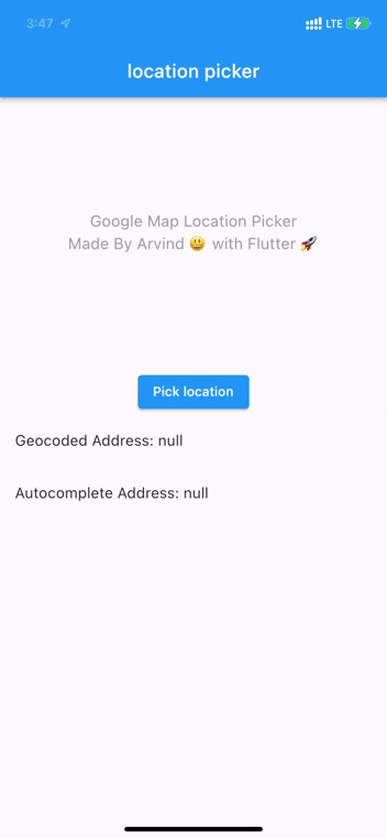
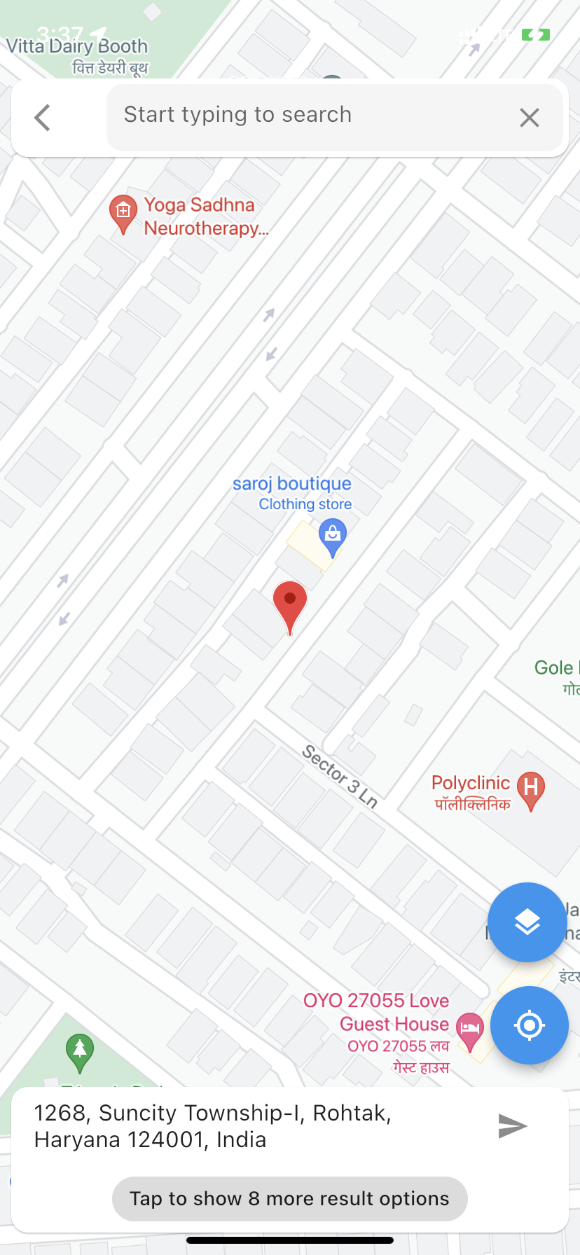
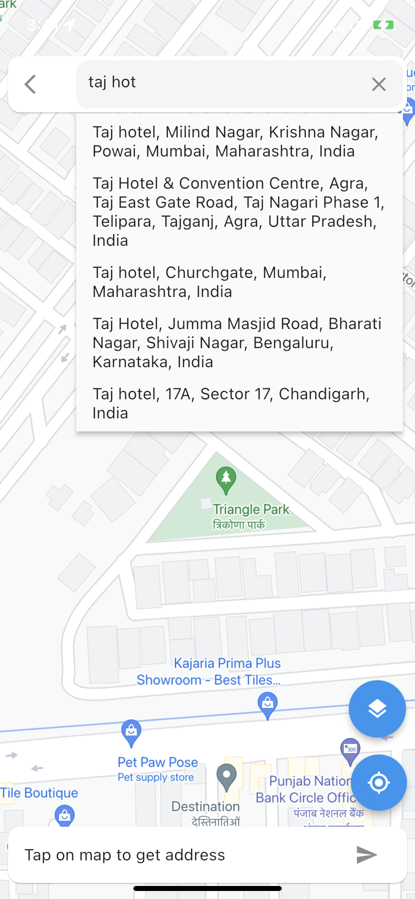
| Video | Decoded Address | Places autocomplete |
 |
 |
 |
Setup #
Pubspec changes:
      dependencies:
        map_location_picker: ^1.2.7
You can now add a GoogleMap widget to your widget tree.
import 'package:map_location_picker/map_location_picker.dart';

MapLocationPicker
(
apiKey: "YOUR_API_KEY",
onNext: (GeocodingResult? result) {
...
},
);
Getting Started #
-
Get an API key at https://cloud.google.com/maps-platform/.
-
And don't forget to enable the following APIs in https://console.cloud.google.com/google/maps-apis/
- Maps SDK for Android
- Maps SDK for iOS
- Places API
- Geocoding API
- Maps JavaScript API
-
And ensure to enable billing for the project.
For more details, see Getting started with Google Maps Platform.
Android #
- Set the
minSdkVersioninandroid/app/build.gradle:
android {
    defaultConfig {
        minSdkVersion 20
    }
}
This means that app will only be available for users that run Android SDK 20 or higher.
- Specify your API key in the application manifest
android/app/src/main/AndroidManifest.xml:
<manifest ...
<application ...
<meta-data android:name="com.google.android.geo.API_KEY"
           android:value="YOUR KEY HERE"/>
Hybrid Composition
To use Hybrid Composition
to render the GoogleMap widget on Android, set AndroidGoogleMapsFlutter.useAndroidViewSurface to
true.
if (defaultTargetPlatform == TargetPlatform.android) {
AndroidGoogleMapsFlutter.useAndroidViewSurface = true;
}
iOS #
To set up, specify your API key in the application delegate ios/Runner/AppDelegate.m:
#include "AppDelegate.h"
#include "GeneratedPluginRegistrant.h"
#import "GoogleMaps/GoogleMaps.h"
@implementation AppDelegate
- (BOOL)application:(UIApplication *)application
    didFinishLaunchingWithOptions:(NSDictionary *)launchOptions {
  [GMSServices provideAPIKey:@"YOUR KEY HERE"];
  [GeneratedPluginRegistrant registerWithRegistry:self];
  return [super application:application didFinishLaunchingWithOptions:launchOptions];
}
@end
Or in your swift code, specify your API key in the application delegate ios/Runner/AppDelegate.swift:
import UIKit
import Flutter
import GoogleMaps
@UIApplicationMain
@objc class AppDelegate: FlutterAppDelegate {
  override func application(
    _ application: UIApplication,
    didFinishLaunchingWithOptions launchOptions: [UIApplication.LaunchOptionsKey: Any]?
  ) -> Bool {
    GMSServices.provideAPIKey("YOUR KEY HERE")
    GeneratedPluginRegistrant.register(with: self)
    return super.application(application, didFinishLaunchingWithOptions: launchOptions)
  }
}
Web View #
Modify web/index.html
Get an API Key for Google Maps JavaScript API. Get started here.
Modify the <head> tag of your web/index.html to load the Google Maps JavaScript API, like so:
<head>
    <!-- // Other stuff -->

    <script src="https://maps.googleapis.com/maps/api/js?key=YOUR_API_KEY"></script>
</head>
Note #
The following permissions are not required to use Google Maps Android API v2, but are recommended.
android.permission.ACCESS_COARSE_LOCATION Allows the API to use WiFi or mobile cell data (or both) to determine the
device's location. The API returns the location with an accuracy approximately equivalent to a city block.
android.permission.ACCESS_FINE_LOCATION Allows the API to determine as precise a location as possible from the
available location providers, including the Global Positioning System (GPS) as well as WiFi and mobile cell data.
You must also explicitly declare that your app uses the android.hardware.location.network or android.hardware.location.gps hardware features if your app targets Android 5.0 (API level 21) or higher and uses the ACCESS_COARSE_LOCATION or ACCESS_FINE_LOCATION permission in order to receive location updates from the network or a GPS, respectively.
<uses-feature android:name="android.hardware.location.network" android:required="false"/>
<uses-feature android:name="android.hardware.location.gps" android:required="false"/>
The following permissions are defined in the package manifest, and are automatically merged into your app's manifest at build time. You don't need to add them explicitly to your manifest:
android.permission.INTERNET Used by the API to download map tiles from Google Maps servers.
android.permission.ACCESS_NETWORK_STATE Allows the API to check the connection status in order to determine whether
data can be downloaded.
Restricting Autocomplete Search to Region #
The Results returned can be restricted to certain countries by passing an array of country codes into the components
parameter of MapLocationPicker. Countries must be two character, ISO 3166-1 Alpha-2 compatible.
You can find code information
at Wikipedia: List of ISO 3166 country codes or
the ISO Online Browsing Platform.
The example below restricts Autocomplete Search to the United Arab Emirates and Nigeria
MapLocationPicker
(
apiKey: "YOUR_API_KEY",
onNext: (GeocodingResult? result) {
...
},
);
See the example directory for a complete sample app.
Parameters of the MapLocationPicker #
/// Padding around the map
final EdgeInsets padding;

/// Compass for the map (default: true)
final bool compassEnabled;

/// Lite mode for the map (default: false)
final bool liteModeEnabled;

/// API key for the map & places
final String apiKey;

/// GPS accuracy for the map
final LocationAccuracy desiredAccuracy;

/// GeoCoding base url
final String? geoCodingBaseUrl;

/// GeoCoding http client
final Client? geoCodingHttpClient;

/// GeoCoding api headers
final Map<String, String>? geoCodingApiHeaders;

/// GeoCoding location type
final List<String> locationType;

/// GeoCoding result type
final List<String> resultType;

/// Map minimum zoom level & maximum zoom level
final MinMaxZoomPreference minMaxZoomPreference;

/// Top card margin
final EdgeInsetsGeometry topCardMargin;

/// Top card color
final Color? topCardColor;

/// Top card shape
final ShapeBorder topCardShape;

/// Top card text field border radius
final BorderRadius? borderRadius;

/// Top card text field hint text
final String searchHintText;

/// Bottom card shape
final ShapeBorder bottomCardShape;

/// Bottom card margin
final EdgeInsetsGeometry bottomCardMargin;

/// Bottom card icon
final Icon bottomCardIcon;

/// Bottom card tooltip
final String bottomCardTooltip;

/// Bottom card color
final Color? bottomCardColor;

/// On Suggestion Selected callback
final Function(PlacesDetailsResponse?)? onSuggestionSelected;

/// On Next Page callback
final Function(GeocodingResult?) onNext;

/// Show back button (default: true)
final bool showBackButton;

/// Popup route on next press (default: false)
final bool canPopOnNextButtonTaped;

/// Back button replacement when [showBackButton] is false and [backButton] is not null
final Widget? backButton;

/// Show more suggestions
final bool showMoreOptions;

/// Dialog title
final String dialogTitle;

/// httpClient is used to make network requests.
final Client? placesHttpClient;

/// apiHeader is used to add headers to the request.
final Map<String, String>? placesApiHeaders;

/// baseUrl is used to build the url for the request.
final String? placesBaseUrl;

/// Session token for Google Places API
final String? sessionToken;

/// Offset for pagination of results
/// offset: int,
final num? offset;

/// Origin location for calculating distance from results
/// origin: Location(lat: -33.852, lng: 151.211),
final Location? origin;

/// Location bounds for restricting results to a radius around a location
/// location: Location(lat: -33.867, lng: 151.195)
final Location? location;

/// Radius for restricting results to a radius around a location
/// radius: Radius in meters
final num? radius;

/// Language code for Places API results
/// language: 'en',
final String? language;

/// Types for restricting results to a set of place types
final List<String> types;

/// Components set results to be restricted to a specific area
/// components: [Component(Component.country, "us")]
final List<Component> components;

/// Bounds for restricting results to a set of bounds
final bool strictbounds;

/// Region for restricting results to a set of regions
/// region: "us"
final String? region;

/// fields
final List<String> fields;
💰You can help me by Donating #
👨🏻💻Contribute to the project #
All contributions are welcome.
👨🏻💻Contributors #
Made with contrib.rocks.
Metadata

Publisher
Metadata
Google Map location picker for flutter Based on google_maps_flutter.
Repository (GitHub)
View/report issues
Topics
#map-picker #location-picker #flutter-location-picker #google-maps-flutter #google-maps
Documentation
License
![]() Apache-2.0 (LICENSE)
Apache-2.0 (LICENSE)
Dependencies
flutter, flutter_typeahead, form_builder_extra_fields, geolocator, google_maps_flutter, google_maps_webapi, http, logger